For the last week, we've been following along as the models converge on a solution for the Birkie next weekend. It's been looking like a cool, dry race for several model runs (good run-to-run continuity) which means it will be probably be snowing or 80 next week. In any case, the last post was getting a bit long-winded, so we'll start the final countdown here.
Feb 20 00Z: Seasonable, dry. 2-4" of snow Wednesday and Thursday.
Feb 20 06Z: Seasonable (10-15), dry. 2-4" snow Wednesday and Thursday.
Feb 20 12Z: Seasonable, dry.
Feb 20 18Z: Seasonable, dry.
Feb 21 00Z: Seasonable, dry. 1-2" snow Tuesday-Wednesday.
Feb 21 06Z: Seasonable (teens), dry. Inch of snow midweek.
Feb 21 12Z: Seasonable (teens), slight possibility of light snow/flurries during race.
Feb 21 18Z: Seasonable (5-15), 1-3" snow midweek.
Feb 22 00Z: Seasonably cool, 1-3" snow midweek.
Feb 22 06Z: Seasonably coo, 1-3" snow midweek. Light northerly wind.
Feb 22 12Z-18Z: It's coming down to 1-2 inches of snow tomorrow (most likely more as you go north on the trail) and temperatures around 5 for the race start (8:30), rising to 20 during the race for fast folks, 30 for later wavers. No more updates unless there are any major changes.
Feb 23 00Z-06Z: Same as before, but with the slight possibility of light snow during the race.
Showing posts with label weather. Show all posts
Showing posts with label weather. Show all posts
Friday, February 19, 2010

Tuesday, February 16, 2010
Birkie Weather Speculation
The long-range models are now reaching to Birkie week. So far it's only the GFS, but it starts to give us an idea of what might be happening two weeks down the road.
I'll make short remarks about each model run between now and then—but don't start waxing quite yet.
Feb 13 00Z: Major warm-up, then light rain, ending, temperatures in the 40s.
Feb 13 06Z: No warm-up, heavy snow (6-12") evening before Birkie.
Feb 13 12Z: Cold (0-10 above), clear.
Feb 13 18Z: Major warm-up, dry.
Feb 14 00Z: Seasonable, dry, no warm-up.
Feb 14 06Z: Seasonable, dry, no warm-up.
Feb 14 12Z: No real warm-up, heavy, wet snowstorm the day before race day.
Feb 14 18Z: Clear and cold (0-10 above).
Feb 15 00Z: Dry or maybe flurries, seasonable.
Feb 15 06Z: Lingering snow, cold (then very cold after race day).
Feb 15 12Z: Possible light snow, cold.
Feb 15 18Z: Clear and chilly.
Feb 16 00Z: Cool, possible flurries.
Feb 16 06Z: Cool, possible warmer storm after Birkie.
Feb 16 12Z: Seasonable, possible snow ending around race time, storm then warm after race.
Feb 16 18Z: Cool, dry, no warmup after race.
Feb 17 00Z: Seasonable, dry.
Feb 17 06Z: Seasonable, dry.
Feb 17 12Z: Cool, dry.
Feb 17 18Z: Cool, dry.
Feb 18 00Z: Seasonable, dry.
Feb 18 06Z: Cool, dry.
Feb 18 12Z: Seasonable, dry.
Feb 18 18Z: Cool, dry.
Feb 19 00Z: Cool, dry.
Feb 19 06Z: Seasonable, probably dry but possible flurries. Possibility of light snow next Wednesday or Thursday to soften conditions for the race.
Feb 19 12Z: Cool, dry. Still a bit of snow showing up between now and race day.
Comments Feb 17: It seems that the model runs are converging on a solution which is for a cool, dry Birkie, probably with a bit of new snow by then, but I bet it will be firm, fast and fun, if a bit nippy. Now, let's see the next model run—if it's anything like normal, it will be completely different than the last few.
I'll continue to update this, hopefully daily, as the race nears—and it will be interesting to see how the model(s) converge on a solution.
I'll make short remarks about each model run between now and then—but don't start waxing quite yet.
Feb 13 00Z: Major warm-up, then light rain, ending, temperatures in the 40s.
Feb 13 06Z: No warm-up, heavy snow (6-12") evening before Birkie.
Feb 13 12Z: Cold (0-10 above), clear.
Feb 13 18Z: Major warm-up, dry.
Feb 14 00Z: Seasonable, dry, no warm-up.
Feb 14 06Z: Seasonable, dry, no warm-up.
Feb 14 12Z: No real warm-up, heavy, wet snowstorm the day before race day.
Feb 14 18Z: Clear and cold (0-10 above).
Feb 15 00Z: Dry or maybe flurries, seasonable.
Feb 15 06Z: Lingering snow, cold (then very cold after race day).
Feb 15 12Z: Possible light snow, cold.
Feb 15 18Z: Clear and chilly.
Feb 16 00Z: Cool, possible flurries.
Feb 16 06Z: Cool, possible warmer storm after Birkie.
Feb 16 12Z: Seasonable, possible snow ending around race time, storm then warm after race.
Feb 16 18Z: Cool, dry, no warmup after race.
Feb 17 00Z: Seasonable, dry.
Feb 17 06Z: Seasonable, dry.
Feb 17 12Z: Cool, dry.
Feb 17 18Z: Cool, dry.
Feb 18 00Z: Seasonable, dry.
Feb 18 06Z: Cool, dry.
Feb 18 12Z: Seasonable, dry.
Feb 18 18Z: Cool, dry.
Feb 19 00Z: Cool, dry.
Feb 19 06Z: Seasonable, probably dry but possible flurries. Possibility of light snow next Wednesday or Thursday to soften conditions for the race.
Feb 19 12Z: Cool, dry. Still a bit of snow showing up between now and race day.
Comments Feb 17: It seems that the model runs are converging on a solution which is for a cool, dry Birkie, probably with a bit of new snow by then, but I bet it will be firm, fast and fun, if a bit nippy. Now, let's see the next model run—if it's anything like normal, it will be completely different than the last few.
I'll continue to update this, hopefully daily, as the race nears—and it will be interesting to see how the model(s) converge on a solution.
Wednesday, February 10, 2010
That was the winter that was—mid-season report
I'd say this is the TW3 report, but the tenses would be wrong, since we're really only about half way through. So, maybe I'll call it TITWTI (this is the winter that is), or something. In any case, it's about time to examine where we stand compared to recent winters, look at some condition reports, and prognosticate where we might wind up, as well as spill some fun weather data. And, yes, there's a darned good reason I did the season recaps after the snow had melted last March: time! So this may be rather short and periodically updated.
Now, we know that ski conditions are, uh, pretty awesome. It got a late start, but since then there has been continuous skiing, with only a couple days without at least good conditions. (Ski conditions were discussed at length last year here.)
So, where do we stand? Well, first of all, we're at, as of February 10, 65 days of skiing, of which 61 have been good or excellent. We have not had to contend with the "oh no will it melt" syndrome which has plagued some past ski seasons, and the base is now up to 15 inches, the highest in nine years, with no meltdowns in sight. The City of Lakes went off without a hitch, Mora will as well, and Birkie has two feet of base two weeks before the race. As long as we can make March 15, we'll have 100 days of skiing, and an "excellent" snow year.
What's interesting is that despite the great skiing since early December (even after a couple of minor meltdowns the trails have, for the most part, been resurrected) it has not been a particularly cold or snowy winter. December was about a degree below normal, January, despite a cold start, finished just a tenth below. Snowfall through the end of January was 26.8 inches, of which 20.9 fell in December (2.8 in October, 0 in November, just 3.1 in January). With 11.3 inches so far in February, we're up to around normal. So it's been a very normal winter.
Despite some variability and unusual storms, there have been no real extremes. We've had no brutal cold snaps (no day has stayed below 0) but also no major warm-ups. The latter is, I think, the reason that we've kept our base so well. If you look back at the past few years, every one has a pretty devastating warm-up. Last January 31 it skied to 45 degrees, a week later it was 47. January '08 hit 40 twice (December '07 had as well), 2007 was, well, let's not talk about it, and other years were similar. It got me to thinking: we haven't been above 40 for more than 70 days. What are the records days under x degrees? I delved in to the data to find out.
Now, we know that ski conditions are, uh, pretty awesome. It got a late start, but since then there has been continuous skiing, with only a couple days without at least good conditions. (Ski conditions were discussed at length last year here.)
So, where do we stand? Well, first of all, we're at, as of February 10, 65 days of skiing, of which 61 have been good or excellent. We have not had to contend with the "oh no will it melt" syndrome which has plagued some past ski seasons, and the base is now up to 15 inches, the highest in nine years, with no meltdowns in sight. The City of Lakes went off without a hitch, Mora will as well, and Birkie has two feet of base two weeks before the race. As long as we can make March 15, we'll have 100 days of skiing, and an "excellent" snow year.
What's interesting is that despite the great skiing since early December (even after a couple of minor meltdowns the trails have, for the most part, been resurrected) it has not been a particularly cold or snowy winter. December was about a degree below normal, January, despite a cold start, finished just a tenth below. Snowfall through the end of January was 26.8 inches, of which 20.9 fell in December (2.8 in October, 0 in November, just 3.1 in January). With 11.3 inches so far in February, we're up to around normal. So it's been a very normal winter.
Despite some variability and unusual storms, there have been no real extremes. We've had no brutal cold snaps (no day has stayed below 0) but also no major warm-ups. The latter is, I think, the reason that we've kept our base so well. If you look back at the past few years, every one has a pretty devastating warm-up. Last January 31 it skied to 45 degrees, a week later it was 47. January '08 hit 40 twice (December '07 had as well), 2007 was, well, let's not talk about it, and other years were similar. It got me to thinking: we haven't been above 40 for more than 70 days. What are the records days under x degrees? I delved in to the data to find out.
| Longest | Second longest | Third longest | ||||
| Temperature | Days | Ending: | Days | Ending: | Days | Ending: |
| 0 | 7 | Jan 7 1912 | 6 | Jan 28 1904 | 5 | Four times |
| 5 | 12 | Jan 12 1912 | 10 | Jan 27 1963 | 9 | Jan 27 1936 |
| 10 | 21 | Feb 7 1936 | 15 | Jan 1912/1974 | 13 | Feb 21 1936 |
| 15 | 36 | Feb 21 1936 | 16 | Jan 1912/1977 | 15 | Jan 12 1974 |
| 20 | 39 | Feb 22 1936 | 25 | Feb 15 1905 | 24 | Feb 12 1904 |
| 25 | 41 | Feb 22 1936 | 32 | Feb 8 1978 | 27 | Three times |
| 27 | 52 | Feb 19 1979 | 47 | Feb 9 1912 | 41 | Feb 22 1936 |
| 29 | 52 | Feb 19 1979 | 50 | Feb 12 1912 | 47 | Feb 22 1978 |
| 30 | 58 | Feb 19 1979 | 52 | Feb 12 1912 | 48 | Feb 25 1939 |
| 31 | 66 | Feb 22 1978 | 58 | Feb 19 1979 | 52 | Feb 13 1912 |
| 32 | 66 | Feb 22 1978 | 58 | Feb 19 1979 | 52 | Feb 13 1912 |
| 33 | 67 | Feb 23 1978 | 58 | Feb 19 1979 | 53 | Feb 13 1912 |
| 34 | 67 | Feb 23 1978 | 60 | Feb 21 1979 | 54 | Feb 13 1912 |
| 35 | 71 | Feb 21 1969 | 70 | Feb 22 1936 | 69 | Feb 15 1971 |
| 36 | 79 | Mar 7 1940 | 77 | Feb 22 1936 | 75 | Mar 15 1975 |
| 37 | 106 | Mar 6 1972 | 84 | Feb 13 1943 | 81 | March 9 1978 |
| 38 | 116 | Mar 12 1979 | 106 | Mar 4 1972 | 105 | Mar 1904/1955 |
| 39 | 122 | Mar 22 1904 | 116 | Mar 12 1979 | 114 | Mar 2 2001 |
| 40 | 122 | Mar 22 1904 | 116 | Mar 12 1979 | 114 | Mar 2 2001 |
| 42 | 126 | Mar 13 2001 | 125 | Mar 24 2006 | 122 | Three times |
| 45 | 141 | Apr 3 1979 | 140 | Apr 12 1975 | 135 | Mar 24 1956 |
| 50 | 152 | Apr 11 1979 | 149 | Three times | 148 | Several times |
Some of these data are pretty amazing. 66 days at or below freezing in 1977-8 is probably the best known. But go a couple degrees warmer, and you get 106 days at or below 37 degrees in 1972, which is, perhaps, just as impressive: it was below 37 from November 21 to March 6! And our last big snow year—the last time Minneapolis banned parking outright on one side of the street. Right now, we have a good chance of overtaking third place for the 37 degree mark, as we are just ten days away (and two weeks out of second). But there have been some impressively long cold streaks in the past. This current streak is long, and cold, but not really historic. Yet.
Thursday, January 21, 2010
Thursday, January 14, 2010
The inversion
The NWS points out that yesterday's evening temperature reading at 850mb (about 5000 feet) was 58 degrees (!) which was not only one of the highest readings ever during winter months but the highest of any balloon in the country. With our inversion, abundant snow cover in the direction of the surface winds and snow to reflect the sun's energy we topped out at all of 28 yesterday. And it doesn't look like the upper air will get that warm any time soon, so the chances of a major meltdown seem to be at bay.
Wednesday, January 13, 2010
Como and snow melting
I hit up Como again for some intervals (double pole then V2 uphill) and all around skiing. The conditions are very good, but it could use a groom. Coverage is full. The issues are that pole plants are soft in places, that the skate lane is getting pretty well packed (although better with warmer weather) and that someone ran a truck across a couple portions of the Glacier, which really needs a regroom. Hopefully they can take the machine across it before the weather turns too warm. Tonight would seem to be a good night for it, hint, hint.
As far as the snow melt goes, I'm actually less concerned now than I was yesterday for two reasons. First, the models are happier. They've backed up the huge, tropical rain storm idea and now just have us hovering in the mid-30s for daytime highs with very little moisture for a week, and then cooling back down. It's not ideal, but it should only take a couple inches off of our base if it comes to pass. As I mentioned earlier, we've dodged a bullet by having had an inversion lock in cold temperatures at the surface; it's still +10˚C at 3000 feet but 20 at the surface, and it never got near freezing today despite some sunshine. It looks like that pattern should continue, with a bit of warm-up but nothing worse than a few hours at 34˚. With January sun, we can handle that.
Second, I went in to the archives and looked at times that 8 or more inches of snow has been on the ground in January (about 40% of the time). I could find no cases where more than 10" of snow had melted in December or January, and only a couple times when 8" had. Here are some interesting analogs to make me less scared that the snow will disappear (although when February comes around, with its stronger sun and warmer temperatures, anything is possible). I can't think of a good way to graphically show this so:
2008: 8" on Jan 3, subsequent days 30/14, 37/19, 41/32, 37/27, 34/22, 31/13, 35/29, no rain or snow, melted to 4"
2005: 7" on Jan 22 melted to 0, but that took until Feb 6 and required highs of 35, 44, 33, and then later 33/28, 25/29, 26/31, 42/27, 50/31, 51/35. That was the City of Lakes Meltdown. We have four more inches of snow and those were extraordinarily high temperatures in February. In addition, there was far less snowcover that year to our south and west.
1993: 9" on the 30th melted to 5 on February 3, but only after 39/12, 45/34, 42/24, 38/22, 38/20 with no other moisture.
1992: 8" of snow on the 1st, aided by 0.8 inches but also hit with about 1/3" of rain, stuck around despite a week with highs around 34 and lows only around 31 (yes, for the first five days of the year the high was 37 and the low was 31). The snow barely melted despite a couple more days in the upper 30s. This seems like a worser-case scenario for our current situation.
1991: 8" on the 31st melted to 0 with temperatures of 43/8, 48/15, 42/35, 46/32; we are not expecting these types of temperatures and the sun was two weeks higher in the sky.
1989: 8" melted to 0 over two-plus weeks (the 8th to the 25th) with highs of 35, 37, 33, 37 (this took it from 6 to 2; it had settled from 8 to 6 already … our snow pack is rather dense so there won't be much settling) and then meted with highs of 39, 40, 40 and 35.
1986 may be the best analog: 12" on the 9th melted to 8" by the 20th, with temperatures of 42/28, 34/27, 44/24, 40/14, 22/6, 25/14, 34/11, 38/21, 39/29, 35/27, 33/28, 34/31 with no rain or snow. This would not be a bad outcome for us.
1976 went from 9 to 7 with a day at 41 and the next at 35.
1974 is another good analog. After a cold start to the month, 8" of snow on the 14th melted to 6 wth days at 39/16, 38/12, 41/24, 33/24, 34/12.
1973 melted 8" to 4" with 38/9, 46/24, 44/24, 36/25.
1952 melted 10" on the 30th to 5" with 42/30, 38/24, 37/21.
The one issue is that moisture would be a major wild card. There are only a couple of instances of a lot of rain falling on a lot of snow in January, and, while they are both a very long time ago, neither actually killed the snow pack. In 1946 melted 10" on the 4th to 4" on the sixth with temperatures of 38/25, 36/33 and 33/25, with 0.6 inches of rain on the middle day. Back in 1902, a December storm brought 0.75" of rain (and 3" of snow) but only depleted the snow pack from 10" to 4" despite 35/17, 34/15, 36/34 (with the rain and wet snow) and 36/28.
So the gist of what I'm saying is that to melt more than 10 inches of snow would require weather so extreme that we've never seen it before. A run-of-the-mill January thaw may eat away at half our base, but to lose more than 8" of snow in January is historically unheard of. Now that the three-inches-of-rain-with-embedded-thunder storm has worked its way off the models, it looks like we'll have a week in the 30s. That we can deal with.
The latest model run has significantly cooler weather in the next week—if it verifies I'd be surprised if we hit freezing more than two days, and then two warmer storms—with some rain or perhaps a lot of wet snow—the week after. So, who knows. If I had to predict, I'd say we have 6" of snow on the ground at the end of the month, with good skiing at most Metro locations and great skiing in Elk River (they are starting with more and they keep snow so damn well).
Ski on.
As far as the snow melt goes, I'm actually less concerned now than I was yesterday for two reasons. First, the models are happier. They've backed up the huge, tropical rain storm idea and now just have us hovering in the mid-30s for daytime highs with very little moisture for a week, and then cooling back down. It's not ideal, but it should only take a couple inches off of our base if it comes to pass. As I mentioned earlier, we've dodged a bullet by having had an inversion lock in cold temperatures at the surface; it's still +10˚C at 3000 feet but 20 at the surface, and it never got near freezing today despite some sunshine. It looks like that pattern should continue, with a bit of warm-up but nothing worse than a few hours at 34˚. With January sun, we can handle that.
Second, I went in to the archives and looked at times that 8 or more inches of snow has been on the ground in January (about 40% of the time). I could find no cases where more than 10" of snow had melted in December or January, and only a couple times when 8" had. Here are some interesting analogs to make me less scared that the snow will disappear (although when February comes around, with its stronger sun and warmer temperatures, anything is possible). I can't think of a good way to graphically show this so:
2008: 8" on Jan 3, subsequent days 30/14, 37/19, 41/32, 37/27, 34/22, 31/13, 35/29, no rain or snow, melted to 4"
2005: 7" on Jan 22 melted to 0, but that took until Feb 6 and required highs of 35, 44, 33, and then later 33/28, 25/29, 26/31, 42/27, 50/31, 51/35. That was the City of Lakes Meltdown. We have four more inches of snow and those were extraordinarily high temperatures in February. In addition, there was far less snowcover that year to our south and west.
1993: 9" on the 30th melted to 5 on February 3, but only after 39/12, 45/34, 42/24, 38/22, 38/20 with no other moisture.
1992: 8" of snow on the 1st, aided by 0.8 inches but also hit with about 1/3" of rain, stuck around despite a week with highs around 34 and lows only around 31 (yes, for the first five days of the year the high was 37 and the low was 31). The snow barely melted despite a couple more days in the upper 30s. This seems like a worser-case scenario for our current situation.
1991: 8" on the 31st melted to 0 with temperatures of 43/8, 48/15, 42/35, 46/32; we are not expecting these types of temperatures and the sun was two weeks higher in the sky.
1989: 8" melted to 0 over two-plus weeks (the 8th to the 25th) with highs of 35, 37, 33, 37 (this took it from 6 to 2; it had settled from 8 to 6 already … our snow pack is rather dense so there won't be much settling) and then meted with highs of 39, 40, 40 and 35.
1986 may be the best analog: 12" on the 9th melted to 8" by the 20th, with temperatures of 42/28, 34/27, 44/24, 40/14, 22/6, 25/14, 34/11, 38/21, 39/29, 35/27, 33/28, 34/31 with no rain or snow. This would not be a bad outcome for us.
1976 went from 9 to 7 with a day at 41 and the next at 35.
1974 is another good analog. After a cold start to the month, 8" of snow on the 14th melted to 6 wth days at 39/16, 38/12, 41/24, 33/24, 34/12.
1973 melted 8" to 4" with 38/9, 46/24, 44/24, 36/25.
1952 melted 10" on the 30th to 5" with 42/30, 38/24, 37/21.
The one issue is that moisture would be a major wild card. There are only a couple of instances of a lot of rain falling on a lot of snow in January, and, while they are both a very long time ago, neither actually killed the snow pack. In 1946 melted 10" on the 4th to 4" on the sixth with temperatures of 38/25, 36/33 and 33/25, with 0.6 inches of rain on the middle day. Back in 1902, a December storm brought 0.75" of rain (and 3" of snow) but only depleted the snow pack from 10" to 4" despite 35/17, 34/15, 36/34 (with the rain and wet snow) and 36/28.
So the gist of what I'm saying is that to melt more than 10 inches of snow would require weather so extreme that we've never seen it before. A run-of-the-mill January thaw may eat away at half our base, but to lose more than 8" of snow in January is historically unheard of. Now that the three-inches-of-rain-with-embedded-thunder storm has worked its way off the models, it looks like we'll have a week in the 30s. That we can deal with.
The latest model run has significantly cooler weather in the next week—if it verifies I'd be surprised if we hit freezing more than two days, and then two warmer storms—with some rain or perhaps a lot of wet snow—the week after. So, who knows. If I had to predict, I'd say we have 6" of snow on the ground at the end of the month, with good skiing at most Metro locations and great skiing in Elk River (they are starting with more and they keep snow so damn well).
Ski on.
I can only get to two trails at most, on a good day! Check out all the trail reports at skinnyski.com
What does it take to melt a foot of snow?
This is a very pertinent question, given the current status of the weather. First of all, we are dodging a bullet for now, given the snow to our southwest and the massive inversion which kept temperatures yesterday in the teens and might keep us well below freezing most of today, even as temperatures aloft are well over 50 degrees! The chart below shows this; blue diagonal lines are temperatures gradients (in C) and the thick red line is the temperature at different levels of the atmosphere. Notice how it starts well below 0 but climbs, quickly, to above 10 (50F). (click the image to enlarge)

If it were going to be 50 for the next two weeks, well, bye bye snow. But it's not. According to the latest model run, the warmest air is in place right now through this afternoon—it's close to 60 (yes, 60 above) higher in the atmosphere, and it's probably 50-50 that it gets to freezing here at the surface today (the sky is still cloudy at 11:00 here in Saint Paul). And while it will remain rather warm for the next few weeks, this is by far the warmest day above, and by not mixing down those warm temperatures, we are really escaping the worst of it.
What happens beyond is a crapshoot. More sun would definitely aid in the depletion of the snow, as would more moisture. However, the models are being rather finicky on how much moisture is going to ride up in to the warm air. Last night, they were showing more than three inches of mostly-melted precipitation in the next two weeks. Now they are showing considerably less. And the most recent runs are showing a split flow with rather consistent temperatures topping our in the 30s for several days, but not skying towards 50 at any point (today would have been the day, but the inversion is helping us). And the temperatures, at least in the short term, should follow a nice diurnal pattern, so that lows will be around 18 around dawn, peak around freezing in the afternoon, and then fall off quickly. This is not a recipe for snow depth disaster.
In any case, back in December I ran the data to look at snow depth during the past 100 years in the Twin Cities. With the current situation, I am going to delve back in to that data and look at what it takes to melt snow in January. I'll look back to find Januaries with snow depths of at least 8 inches, and see what the weather was following. In other words, I want to know what it would take, weather-wise, to melt our base.
(Why just January? In January the sun is within a few degrees of the solstice, i.e. not very high. Come February and especially March, as the sun gets higher in the atmosphere its effect on snow melt increases dramatically, even if it is not reflected in the temperatures. Day lengths matter as well. Do data from past Februaries and Marches, when you can melt a foot of snow with two sunny, 50 degree days, is not particularly pertinent.)
23 megabytes of data have to be good for something, right?

What happens beyond is a crapshoot. More sun would definitely aid in the depletion of the snow, as would more moisture. However, the models are being rather finicky on how much moisture is going to ride up in to the warm air. Last night, they were showing more than three inches of mostly-melted precipitation in the next two weeks. Now they are showing considerably less. And the most recent runs are showing a split flow with rather consistent temperatures topping our in the 30s for several days, but not skying towards 50 at any point (today would have been the day, but the inversion is helping us). And the temperatures, at least in the short term, should follow a nice diurnal pattern, so that lows will be around 18 around dawn, peak around freezing in the afternoon, and then fall off quickly. This is not a recipe for snow depth disaster.
In any case, back in December I ran the data to look at snow depth during the past 100 years in the Twin Cities. With the current situation, I am going to delve back in to that data and look at what it takes to melt snow in January. I'll look back to find Januaries with snow depths of at least 8 inches, and see what the weather was following. In other words, I want to know what it would take, weather-wise, to melt our base.
(Why just January? In January the sun is within a few degrees of the solstice, i.e. not very high. Come February and especially March, as the sun gets higher in the atmosphere its effect on snow melt increases dramatically, even if it is not reflected in the temperatures. Day lengths matter as well. Do data from past Februaries and Marches, when you can melt a foot of snow with two sunny, 50 degree days, is not particularly pertinent.)
23 megabytes of data have to be good for something, right?
Saturday, January 9, 2010
Now I'm concerned
The long-range GFS model that came out shows way too much warm air for my liking. Pretty please have it be wrong.
Friday, January 8, 2010
Why I am not too, too concerned about the thaw next week

I hope.
More locally, check out the latest snow depth maps from the U.

I hope.
In any case, we are entering a dreaded split-flow situation, which brings warm, dry air to the area. We can only hope it is short-lived and does not do much to our base, and good, cold, moist weather returns soon.
Friday, December 25, 2009
How bizarre is this storm?
Winds switched from NE to S, and the temperature dropped twenty degrees.
Seriously.
Seriously.
Tuesday, December 22, 2009
Weather speculation: let the fun begin
I spend way too much time watching as each model run comes in. Ooh, the 12Z GFS! The 15Z SREF! In any case, the numbers are in flux, but a foot looks rather likely. Two feet is definitely not out of the question. The variables right now are whether any non-snow precipitation gets as far north as the Twin Cities (about 50-50 right now) and what the final QPF amounts are. That said, I'd bet someone gets two feet.
Sunday, December 20, 2009
Weather Speculation: Bullseye
During my time in the Twin Cities (since 2002), there's never been a real, proper snowstorm. There were a couple big storms in March (but what good do those do other than melt a week later?) and there have been several which have dumped snow to the east, west or north, but the Cities seem to have been in hole the whole time. As far as I can remember, we've not had a midwinter, foot-plus storm in, well, a long time.
That may change. The latest GFS has a 990mb low pressure center shooting straight up from the Gulf and stalling around La Crosse, spreading heavy snow and wind (all out blizzard) over much of Minnesota. (This is rather in line with the earlier ECMWF run I talked about this afternoon.) The rain snow line would set up from about Sioux City to Albert Lea to Eau Claire. North of this line would see somewhere in the range of 1.5 to 1.75 inches of snow-water equivalent, with a snow:water ratio of at least 10:1 and probably closer to 15:1. The math there works out to 15 to 26 inches, with more in Duluth off the lake. That's a crippling, shut down the highways and ski down the streets, snowstorm. Travel on Christmas Eve would be impossible. Is anyone else excited?

(QPF is shown to the left, with approximate snow amounts; the very-approximate rain-snow line is shown with yellow dots)
Just plain wow. That's the printout from the 00z GFS run for the 60 hours ending 7 a.m. on Saturday (i.e. 7 p.m. Wednesday to 7 a.m. Saturday) and it would snow much of this time. A white Christmas indeed. Things can change and probably will, but if this came to pass, it would be an absolutely epic snowstorm.
One more thing: although the situations are somewhat different—it's not October, and we don't have a cold front having just come through, and there's not a hurricane buckling the weather off the Eastern Seaboard (although Nantucket did have wind gusts of 60 mph this morning)—but this snow map looks almost-plausible given this weather system:

That is, of course, the Hallowe'en Blizzard of 1991. Which was also a low which shot nearly due north from the Gulf of Mexico in to cold air. (There's a great video on MinnPost about the storm, which was overshadowed by the "Perfect Storm" on the East Coast, but the two weather systems were interrelated—the Perfect Storm interrupted the jet stream, allowing a storm which would normally go east to go almost due north.)
Skiing could get very, very excellent soon for a long time to come (the models don't show near-freezing temperatures any time soon). Stay sharply tuned. …
That may change. The latest GFS has a 990mb low pressure center shooting straight up from the Gulf and stalling around La Crosse, spreading heavy snow and wind (all out blizzard) over much of Minnesota. (This is rather in line with the earlier ECMWF run I talked about this afternoon.) The rain snow line would set up from about Sioux City to Albert Lea to Eau Claire. North of this line would see somewhere in the range of 1.5 to 1.75 inches of snow-water equivalent, with a snow:water ratio of at least 10:1 and probably closer to 15:1. The math there works out to 15 to 26 inches, with more in Duluth off the lake. That's a crippling, shut down the highways and ski down the streets, snowstorm. Travel on Christmas Eve would be impossible. Is anyone else excited?

Just plain wow. That's the printout from the 00z GFS run for the 60 hours ending 7 a.m. on Saturday (i.e. 7 p.m. Wednesday to 7 a.m. Saturday) and it would snow much of this time. A white Christmas indeed. Things can change and probably will, but if this came to pass, it would be an absolutely epic snowstorm.
One more thing: although the situations are somewhat different—it's not October, and we don't have a cold front having just come through, and there's not a hurricane buckling the weather off the Eastern Seaboard (although Nantucket did have wind gusts of 60 mph this morning)—but this snow map looks almost-plausible given this weather system:
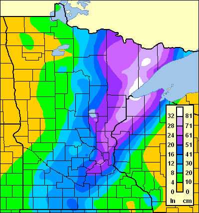
That is, of course, the Hallowe'en Blizzard of 1991. Which was also a low which shot nearly due north from the Gulf of Mexico in to cold air. (There's a great video on MinnPost about the storm, which was overshadowed by the "Perfect Storm" on the East Coast, but the two weather systems were interrelated—the Perfect Storm interrupted the jet stream, allowing a storm which would normally go east to go almost due north.)
Skiing could get very, very excellent soon for a long time to come (the models don't show near-freezing temperatures any time soon). Stay sharply tuned. …
What do I want for Christmas?
Well, a foot of new snow would be nice.
There's chit-chat of some sort of storm moving through the Upper Mississippi Valley this coming week, and, well, it's well placed, but I remain somewhat skeptical. Why? Because until three days ago we didn't know if the East Coast was going to get a lot of snow or not. (If you're following along, they did. If you are trying to fly to the East Coast this weekend, well, you probably are still in Minnesota.) The models there bounced around inordinately, and the GFS and the ECMWF, the two longer-range models, had different solutions until about 48 hours before the storm. Washington, New York and Boston all had scenarios where they'd see two feet and other where they'd see sunny skies over the weekend, and the models only resolved in the last couple of days. So, anything put forth is almost pure speculation and while I wouldn't be too surprised to see a deep snowpack by Friday morning, I also wouldn't be surprised if we just had sun and starts (and Santa Claus) in the skies.
Let's go, as it were, to the video tape. Here are the last two runs of the GFS model, each printing out a foot of snow, or so, from Minnesota. Wisconsin gets the jackpot (as usual, it seems) but the North Shore gets hit, too, which they need up there. Either of these scenarios would be fine with me, but the models have been wobbly enough I'm not getting too excited. Yet.


On the other hand, the ECMWF, which doesn't show QPF, is intriguing because it seems to bring the storm up a bit closer to the Twin Cities. The latest ECMWF model run is further to the west of that storm track and could, presumably, shift the axis of heaviest snow in to Minnesota. The printout of the 12Z ECMWF vs the 12Z GFS shows how the models are still quite different.

This map shows the models, with the ECMWF in orange and the GFS in green, at 7 a.m. on the 25th (120 hours out from the model run). I've included the locations of the center of the low on the 24th (96 hours out) and 26th (144 hours out) for comparison. The GFS takes the low almost due north from Central Arkansas to near Milwaukee, and then retrogrades it (retrograding means that does not follow the normal east-west pattern) to near Watersmeet in the UP. This is the scenario which would dump snow heaviest in a Madison-Wausau corridor. But look at the ECMWF. It starts further west, near Texarkana, and goes due north to near Des Moines, before turning to the east. This would seem to throw the heaviest snow from Omaha to Sioux City to Minneapolis and Birkieland.
And I'm inclined to believe this model for two reasons. First, while all the models have been pretty bad this year, the ECMWF has been slightly better than the GFS. In the recent East Coast storm, the EC started with the coastal storm which eventuated, while the GFS was much further east and came back west with time. The second reason I believe the ECMWF a bit more is that it's generally more likely to have a normal east-west pattern than a retrograde, so the west-to-east movement of the GFS seems less likely.
In any case, it will be quite telling in the next couple of days as to what happens—whether we'll have two feet of snow on the ground by Christmas. Okay, that's an exaggeration. Maybe.
(There might be a couple inches before then, but it appears more likely to go south of us.)
Update: the latest Canadian GEM model seems to split the difference, although it has a pretty dramatic precipitation cutoff near the Twin Cities.
There's chit-chat of some sort of storm moving through the Upper Mississippi Valley this coming week, and, well, it's well placed, but I remain somewhat skeptical. Why? Because until three days ago we didn't know if the East Coast was going to get a lot of snow or not. (If you're following along, they did. If you are trying to fly to the East Coast this weekend, well, you probably are still in Minnesota.) The models there bounced around inordinately, and the GFS and the ECMWF, the two longer-range models, had different solutions until about 48 hours before the storm. Washington, New York and Boston all had scenarios where they'd see two feet and other where they'd see sunny skies over the weekend, and the models only resolved in the last couple of days. So, anything put forth is almost pure speculation and while I wouldn't be too surprised to see a deep snowpack by Friday morning, I also wouldn't be surprised if we just had sun and starts (and Santa Claus) in the skies.
Let's go, as it were, to the video tape. Here are the last two runs of the GFS model, each printing out a foot of snow, or so, from Minnesota. Wisconsin gets the jackpot (as usual, it seems) but the North Shore gets hit, too, which they need up there. Either of these scenarios would be fine with me, but the models have been wobbly enough I'm not getting too excited. Yet.


This map shows the models, with the ECMWF in orange and the GFS in green, at 7 a.m. on the 25th (120 hours out from the model run). I've included the locations of the center of the low on the 24th (96 hours out) and 26th (144 hours out) for comparison. The GFS takes the low almost due north from Central Arkansas to near Milwaukee, and then retrogrades it (retrograding means that does not follow the normal east-west pattern) to near Watersmeet in the UP. This is the scenario which would dump snow heaviest in a Madison-Wausau corridor. But look at the ECMWF. It starts further west, near Texarkana, and goes due north to near Des Moines, before turning to the east. This would seem to throw the heaviest snow from Omaha to Sioux City to Minneapolis and Birkieland.
And I'm inclined to believe this model for two reasons. First, while all the models have been pretty bad this year, the ECMWF has been slightly better than the GFS. In the recent East Coast storm, the EC started with the coastal storm which eventuated, while the GFS was much further east and came back west with time. The second reason I believe the ECMWF a bit more is that it's generally more likely to have a normal east-west pattern than a retrograde, so the west-to-east movement of the GFS seems less likely.
In any case, it will be quite telling in the next couple of days as to what happens—whether we'll have two feet of snow on the ground by Christmas. Okay, that's an exaggeration. Maybe.
(There might be a couple inches before then, but it appears more likely to go south of us.)
Update: the latest Canadian GEM model seems to split the difference, although it has a pretty dramatic precipitation cutoff near the Twin Cities.
Sunday, December 6, 2009
Storm speculation update
With the latest model runs in, everything looks on-target. The Winter Storm Watches are up, and we're looking at 5-8 inches of snow Tuesday in to Wednesday. The NAM, which had been advertising less snow, is trending slightly more, the GFS, which had been higher, going slightly less. Still, we're looking good. Light, fluffy, and not falling too hard, although it will cause some driving nightmares I bet (skiing, on the other hand …). Wax 'em up!
9:00 a.m. Monday: still looking good. GFS and NAM both have the 0.5" QPF (quantity of precipitation) running through the Twin Cities. At 15:1 snow rations, that's 7.5 inches. Pretty good. Pretty, pretty, pretty, pretty good.
2:30 p.m. Monday: the latest NAM has us up to 7.5 QPF, which would be close to a foot of snow. Stay tuned …
9:00 a.m. Monday: still looking good. GFS and NAM both have the 0.5" QPF (quantity of precipitation) running through the Twin Cities. At 15:1 snow rations, that's 7.5 inches. Pretty good. Pretty, pretty, pretty, pretty good.
2:30 p.m. Monday: the latest NAM has us up to 7.5 QPF, which would be close to a foot of snow. Stay tuned …
Saturday, December 5, 2009
Storm speculation
For a while, the models have been hinting at a storm for the middle of next work. A big one. Three feet of snow in the mountains of Colorado, with the low then ejecting east across the Plains. At first, the models suggested that the snow would generally stay south of the Twin Cities, but recent model runs, while not changing the track significantly, have suggested that an inverted trough on the back side of the storm will sit in the Upper Midwest, setting down several inches of snow.
The National Weather Service is excited. With cold temperatures, they are preliminarily talking about seven or eight inches of snow. But they are excited because looking at analog patterns—similar situations in the past—show a storm from January of 1982, which dumped about a foot and a half of snow on the Twin Cities (one of two such storms in a three day period, leading to the greatest snow depth—38 inches—ever recorded, quite literally off the charts). But, even a foot and a half would be exciting enough!
(Again, no guarantees here; the NAM model is not biting to the same degree. We'll see.)
The National Weather Service is excited. With cold temperatures, they are preliminarily talking about seven or eight inches of snow. But they are excited because looking at analog patterns—similar situations in the past—show a storm from January of 1982, which dumped about a foot and a half of snow on the Twin Cities (one of two such storms in a three day period, leading to the greatest snow depth—38 inches—ever recorded, quite literally off the charts). But, even a foot and a half would be exciting enough!

(Again, no guarantees here; the NAM model is not biting to the same degree. We'll see.)
Sunday, November 22, 2009
More weather hype: snow for Thanksgiving?
There's a chance I might get to pull a Larry David—to be happy and cheery at others' expense. Why? Because on the upcoming biggest travel day of the year, Wednesday, we might get just enough snow to a) ski on and b) tie up traffic something awful.
Let me stress: might.
The models, this time of year, are less than stellar. Wednesday is still three days away. However, for several consecutive runs, the GFS model has bullseyed an area of QPF (precipitation) over the Twin Cities, with most of it looking to fall as snow on the back side of a progression of lows. Before you get too excited, consider the aforementioned inaccuracy of the models, the other models not quite showing the same thing (the NAM has most snow further east), the fact that this is a small area of precipitation so a small shift of a few dozen miles could make or break the deal, and the fact that the temperature will be near freezing, so a few degrees could make for a cold rain.
Now that I've sufficiently dampened enthusiasm, let's go to the video tape (as it were). Last night's 00Z (midnight CST for the GFS) model run showed the precipitation east of here. Since then, the following are the approximate QPF estimates for once the air column cools enough for snow. Here are 06Z, 12Z and 18Z runs. The contours are 0.01", 0.1", 0.25", 0.5" and upwards; 0.5" being dark blue.


So … that's three straight model runs with us getting at least three inches of snow, or so. This is all spun out the back of a second system and will hit warm, wet ground, so there's no telling how much will actually fall. But, it's certainly more than nothing. The next few runs should be very interesting, indeed, as well as whether other models jump on board. There will be much more to know to know tomorrow, and remember, IANAM (I am not a meteorologist).
A bit of good news if it does snow (or even if it doesn't): the models are showing a more muted warmup next weekend before the real cold comes in, so if we get a few inches of snow, with the current low sun angle, it might not all melt completely. Winter is certainly late, but it should be coming soon.
Let me stress: might.
The models, this time of year, are less than stellar. Wednesday is still three days away. However, for several consecutive runs, the GFS model has bullseyed an area of QPF (precipitation) over the Twin Cities, with most of it looking to fall as snow on the back side of a progression of lows. Before you get too excited, consider the aforementioned inaccuracy of the models, the other models not quite showing the same thing (the NAM has most snow further east), the fact that this is a small area of precipitation so a small shift of a few dozen miles could make or break the deal, and the fact that the temperature will be near freezing, so a few degrees could make for a cold rain.
Now that I've sufficiently dampened enthusiasm, let's go to the video tape (as it were). Last night's 00Z (midnight CST for the GFS) model run showed the precipitation east of here. Since then, the following are the approximate QPF estimates for once the air column cools enough for snow. Here are 06Z, 12Z and 18Z runs. The contours are 0.01", 0.1", 0.25", 0.5" and upwards; 0.5" being dark blue.
So … that's three straight model runs with us getting at least three inches of snow, or so. This is all spun out the back of a second system and will hit warm, wet ground, so there's no telling how much will actually fall. But, it's certainly more than nothing. The next few runs should be very interesting, indeed, as well as whether other models jump on board. There will be much more to know to know tomorrow, and remember, IANAM (I am not a meteorologist).
A bit of good news if it does snow (or even if it doesn't): the models are showing a more muted warmup next weekend before the real cold comes in, so if we get a few inches of snow, with the current low sun angle, it might not all melt completely. Winter is certainly late, but it should be coming soon.
Wednesday, November 18, 2009
Don't believe the hype
If you listened to Minnesota Public Radio this morning, you probably heard a conversation between the host and one of their meteorologists (who blog at the Updraft Blog, which is very good). They were talking about the possibility for a snowstorm on Monday, and made it sounds, well, not like a done deal, but like a definite possibility.
Don't get excited. This is not the case.
Is there a chance of a slight snowfall next week? Yes. Sure. The pattern will be changing somewhat, and there's a lot of energy hurling through the system which could wind up and dump some snow somewhere over the upper-Midwest. Is it something that has been on the model runs over a couple of days? Not so much. Last night's GFS (the 00z run, which comes out around 11 p.m. CST) showed a possibility of a minor snow event on Monday, with marginal heights, resulting in a wet snow which would probably melt on the warm ground. The 06z showed something similar. The most recent run shows, well, maybe some snow over Chicago? Who knows.
So, yes, there's a possibility. Keep your eye out. But I wouldn't scrape the storage wax off the good skis just yet.
(The good news is that the models are hinting at a proper winter pattern around the first of December.)
Don't get excited. This is not the case.
Is there a chance of a slight snowfall next week? Yes. Sure. The pattern will be changing somewhat, and there's a lot of energy hurling through the system which could wind up and dump some snow somewhere over the upper-Midwest. Is it something that has been on the model runs over a couple of days? Not so much. Last night's GFS (the 00z run, which comes out around 11 p.m. CST) showed a possibility of a minor snow event on Monday, with marginal heights, resulting in a wet snow which would probably melt on the warm ground. The 06z showed something similar. The most recent run shows, well, maybe some snow over Chicago? Who knows.
So, yes, there's a possibility. Keep your eye out. But I wouldn't scrape the storage wax off the good skis just yet.
(The good news is that the models are hinting at a proper winter pattern around the first of December.)
Tuesday, October 6, 2009
Early weather speculation
No, no, it's not ski season yet. Somewhere, maybe. Montana? Norway? Not here. … Yet.
Actually, likely not here for a little while. But it doesn't mean we can't have a bit of weather speculation. First off, the NWS points out that if today's rain storm were hitting a month later
Then, well, there's this weekend, when we may see some snow. Probably not enough to accumulate, and since it has yet to drop below freezing the ground will not hold it. But we may see snow, as it will be cold enough that anything that falls will be solid and white. (Not bad, considering our average high is still in the low 60s.) This weekend will be considerably colder; highs may struggle to reach 40 on Saturday or Sunday.
Why do I mention this? Because the last time it was this cold, this early, ABR had good skiing. On October 12, 2006, the high in Minneapolis was 39. In Ironwood it was 30 and they had 18 inches of snow, and ABR groomed. It's not currently forecast to be quite that cold. And lake effect definitely depends on how the winds set up, not just how cold it is (although the westerly winds forecast would be good). In any case, keep your eye on the UP next weekend. I'm not saying it will snow, but I've looked back to 1970 and there are no colder days in the first half of October. If we have a high below 40 and a low in the mid-20s, watch ABR indeed.
In other words, I'll be taking rock skis to the Whistlestop Marathon.
Actually, likely not here for a little while. But it doesn't mean we can't have a bit of weather speculation. First off, the NWS points out that if today's rain storm were hitting a month later
IF THIS WAS EARLY NOVEMBER...OUR REGION WOULD BE TALKING ABOUT HEAVY SNOWFALL NOT ONE TO TWO INCHES OF RAIN.Alas, we just don't have the elevation. (I was at 4300 feet in New England last week and it was snowing lightly.)
Then, well, there's this weekend, when we may see some snow. Probably not enough to accumulate, and since it has yet to drop below freezing the ground will not hold it. But we may see snow, as it will be cold enough that anything that falls will be solid and white. (Not bad, considering our average high is still in the low 60s.) This weekend will be considerably colder; highs may struggle to reach 40 on Saturday or Sunday.
Why do I mention this? Because the last time it was this cold, this early, ABR had good skiing. On October 12, 2006, the high in Minneapolis was 39. In Ironwood it was 30 and they had 18 inches of snow, and ABR groomed. It's not currently forecast to be quite that cold. And lake effect definitely depends on how the winds set up, not just how cold it is (although the westerly winds forecast would be good). In any case, keep your eye on the UP next weekend. I'm not saying it will snow, but I've looked back to 1970 and there are no colder days in the first half of October. If we have a high below 40 and a low in the mid-20s, watch ABR indeed.
In other words, I'll be taking rock skis to the Whistlestop Marathon.
Saturday, April 4, 2009
On the other hand
Real meteorologists take in to account all the models, look at various other data, use thinks like the bufkit (Pretty much a software package, or "kit", from the Buffalo office of the NWS, or "buf", which I don't have.) and such to make real forecasts. The NWS is down to "less than an inch," probably because of the dry air in place early on when QPF overspreads the area. Which will at least keep things dry. What good is three inches of snow in April, anyway?
Friday, April 3, 2009
Skunked again ... or not?
It looks like we will have reaped two inches, maybe three, out of two storms which dump a foot over the northern half and southern fringe of Minnesota. Stuck in the middle. Again. I'm not bitter, as we had a decent snow season, and it's not like we really need one day of mediocre skiing in April. It's just that, gosh, I like snow.
Tomorrow's storm offers a faint glimmer of home on two scales. On a large scale, we've seen the models move storms north over the last few hours. It happened, big-time, last week. (Sunday the folks in Elk River were talking about grooming; Tuesday they had white grass.) And this time, the NAM pushed snow north. Then south. So, is it to be trusted? Nah.
Then there's the GFS. It's been rather steady; according to the latest AFD, it's been the model of choice. And through it's 12z run, it's put the heaviest band of snow through about Albert Lea. So we'll see if the 18z run looks any better.
For pure speculation, let's look at the ARW forecast. It's a finer-scale forecast and only goes to 48 hours, but look: It, uh, shows us as having more than 0.5 inches of QPF (4-8 inches of snow) halfway through the storm. Okay, that's getting interesting. It had the snow band south in its 00z run, and then jumped 100 miles north for the 06z and 12z. That is interesting.
Now, the 18z GFS is just coming out. And... ...everything is shifted north. In one run, everything is up 75 miles. The Cities are not in the bullseye, but all of a sudden this is a "plowable storm" if not more. Take a look at the same time period, one run earlier:
There are a few contours of note. The 0.25 QPF contour (dark green) has moved north from about Rush City to Cloquet. The 0.5 contour (dark blue) went from Hastings to Hinckley. The 1.0 inch contour moved a bit less, but still went from Albert Lea to Northfield. This would put down a foot of snow from I-90 to Northfield, and 6-12 inches for the Metro. It might just be a stronger or differently-shaped storm (the southern contours changed less). Time, I guess will tell.
The snow, should it come, would not be necessary. It would make the trails muddier and wetter for some time. And it might give us a day or two of skiing. I'd be downright enthralled if it were December. For now, I'll just keep a close eye on the models as they roll through.
Tomorrow's storm offers a faint glimmer of home on two scales. On a large scale, we've seen the models move storms north over the last few hours. It happened, big-time, last week. (Sunday the folks in Elk River were talking about grooming; Tuesday they had white grass.) And this time, the NAM pushed snow north. Then south. So, is it to be trusted? Nah.
Then there's the GFS. It's been rather steady; according to the latest AFD, it's been the model of choice. And through it's 12z run, it's put the heaviest band of snow through about Albert Lea. So we'll see if the 18z run looks any better.
For pure speculation, let's look at the ARW forecast. It's a finer-scale forecast and only goes to 48 hours, but look:
 It, uh, shows us as having more than 0.5 inches of QPF (4-8 inches of snow) halfway through the storm. Okay, that's getting interesting. It had the snow band south in its 00z run, and then jumped 100 miles north for the 06z and 12z. That is interesting.
Now, the 18z GFS is just coming out. And...
 ...everything is shifted north. In one run, everything is up 75 miles. The Cities are not in the bullseye, but all of a sudden this is a "plowable storm" if not more. Take a look at the same time period, one run earlier:
There are a few contours of note. The 0.25 QPF contour (dark green) has moved north from about Rush City to Cloquet. The 0.5 contour (dark blue) went from Hastings to Hinckley. The 1.0 inch contour moved a bit less, but still went from Albert Lea to Northfield. This would put down a foot of snow from I-90 to Northfield, and 6-12 inches for the Metro. It might just be a stronger or differently-shaped storm (the southern contours changed less). Time, I guess will tell.
The snow, should it come, would not be necessary. It would make the trails muddier and wetter for some time. And it might give us a day or two of skiing. I'd be downright enthralled if it were December. For now, I'll just keep a close eye on the models as they roll through.
Subscribe to:
Posts (Atom)