That may change. The latest GFS has a 990mb low pressure center shooting straight up from the Gulf and stalling around La Crosse, spreading heavy snow and wind (all out blizzard) over much of Minnesota. (This is rather in line with the earlier ECMWF run I talked about this afternoon.) The rain snow line would set up from about Sioux City to Albert Lea to Eau Claire. North of this line would see somewhere in the range of 1.5 to 1.75 inches of snow-water equivalent, with a snow:water ratio of at least 10:1 and probably closer to 15:1. The math there works out to 15 to 26 inches, with more in Duluth off the lake. That's a crippling, shut down the highways and ski down the streets, snowstorm. Travel on Christmas Eve would be impossible. Is anyone else excited?

Just plain wow. That's the printout from the 00z GFS run for the 60 hours ending 7 a.m. on Saturday (i.e. 7 p.m. Wednesday to 7 a.m. Saturday) and it would snow much of this time. A white Christmas indeed. Things can change and probably will, but if this came to pass, it would be an absolutely epic snowstorm.
One more thing: although the situations are somewhat different—it's not October, and we don't have a cold front having just come through, and there's not a hurricane buckling the weather off the Eastern Seaboard (although Nantucket did have wind gusts of 60 mph this morning)—but this snow map looks almost-plausible given this weather system:
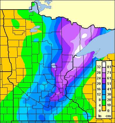
That is, of course, the Hallowe'en Blizzard of 1991. Which was also a low which shot nearly due north from the Gulf of Mexico in to cold air. (There's a great video on MinnPost about the storm, which was overshadowed by the "Perfect Storm" on the East Coast, but the two weather systems were interrelated—the Perfect Storm interrupted the jet stream, allowing a storm which would normally go east to go almost due north.)
Skiing could get very, very excellent soon for a long time to come (the models don't show near-freezing temperatures any time soon). Stay sharply tuned. …
No comments:
Post a Comment